
Aquifer System Hydrogeologic Characterization
Understanding how water moves and interacts in the aquifer is essential to effectively managing our groundwater. One tool that groundwater managers use to understand what is happening in an aquifer is a hydrologic model, which is a simplified conceptual and computer model that helps simulate and predict the use and movement of groundwater. To function properly, these models need accurate local information to base the model assumptions on. From 2024 to 2026, the GSA used grant funding from the Department of Water Resources to improve the understanding of the aquifer system hydrogeologic framework, distribution, and potential effects of faults on groundwater flow, and basin boundary characteristics through analysis of existing and new geophysical data and strategically designed aquifer testing.
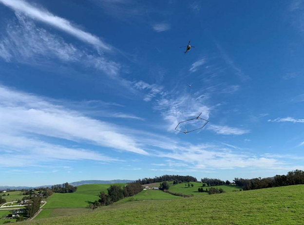
One way we assess what our aquifer looks like underground is through aerial electromagnetic (AEM) surveys and checking that the results make sense with ground-based surveys of wells, known as “ground-truthing.” AEM surveys are a relatively new technology that provides valuable insights into what is occurring underground. The process includes flying a helicopter over the land surface that contains the groundwater basin and taking measurements of how the properties of soil, rocks and water change at different depths below ground surface. The AEM surveys help the GSA understand the existing conditions and potential risks to beneficial groundwater users from groundwater pumping and potential surface water depletion.
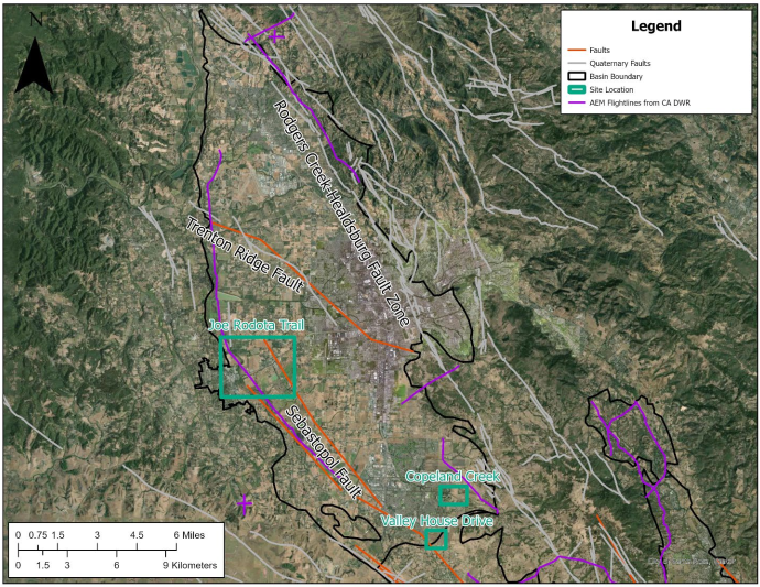
The Santa Rosa Plain GSA recently completed ground-based geophysical surveys with Collier Geophysics and Ramboll to fill remaining data gaps and ground-truth the AEM surveys that were conducted by the Department of Water Resources (DWR) in 2022 (More information on DWR’s AEM flights available here). The map below shows the flight path of the AEM surveys and the three sites that were used to compare: a portion of the Joe Rodota Trail, Copeland Creek, and an undeveloped parcel south of Valley House Drive. To learn more about the results of these geophysical surveys, you can read the full report here. This information, along with a multitude of other improvements, were added to the hydrologic groundwater model to better estimate aquifer conditions. You can read about the full extent of updates to the model here.
Another way the GSA has improved the understanding of the aquifer system is by conducting aquifer testing. Aquifer tests are field experiments that include pumping at a controlled rate while monitoring the resulting water levels. This is an extremely reliable method for developing key hydraulic properties of our aquifer, like transmissivity and storage capacity. Transmissivity is the rate at which water moves through an aquifer; knowing this information gives us a better understanding of well yields, predicting contaminant transport, and managing sustainable groundwater extraction rates. Aquifer testing was previously conducted in 2013 by the U.S. Geological Survey (USGS). The GSA sought to update this information in 2022 at Sonoma Water’s Sebastopol Road Well, in 2024 at Sonoma Water’s Occidental Road Well, and in 2025 at the City of Santa Rosa’s Martha Way Well. This updated test showed that transmissivity estimates ranged from 12,200 gallons per day per foot to 26,200 gallons per day per foot at the Sebastopol Road and Occidental Road Wells. Transmissivity estimates ranged from 21,000 gallons per day per foot to 191,000 gallons per day per foot at the Martha Way Well. To learn more about this study, read the full report here. While this information was not included in the hydrologic model update, it is planned to be incorporated in future model updates. Future work could include testing other areas of the basin that have different geologic properties.